.
Upper Allen Township recommends changes to County Future Land Use Map affecting about 350 acres
September 10, 2025
On August 20, 2025, the Upper Allen Township Commissioners voted 4-1 to recommend changes to the Cumberland County Future Land Use (FLU) Map as adopted by the Cumberland County Commissioners on December 19, 2024. This map is part of the County’s new Comprehensive Plan.
The new FLU map had changed several hundred acres near East Lisburn Rd., McCormick Rd. and Bishop Rd. from “Agricultural/Rural” (2017 map) to “Suburban” (2024 map).
Suburban is a broad land use category that includes (per the County’s definition) everything from single family housing, townhomes, apartments, commercial retail, office, and industrial uses with operations compatible with surrounding community.
This change was of concern to landowners, residents, and Commissioners Fairchild and Walsh because: some owners were unaware of the change, it had not been reviewed or discussed at the Township level, it was not in keeping with the character of the area, and it could lead to requests to change Upper Allen Zoning so as to be “consistent” with the County’s map.
The Upper Allen recommendation is to change about 350 acres in this area back to “Rural”.
Special thanks to Kirk Stoner and Stephanie Williams of County Planning who were most helpful in providing additional information and attending Township meetings to answer questions. The County had previously agreed to amend its map to reflect the UAT recommended changes.
.
Future Development
April 26, 2025
.
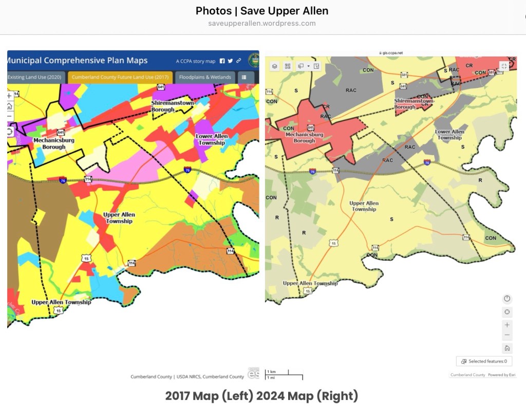
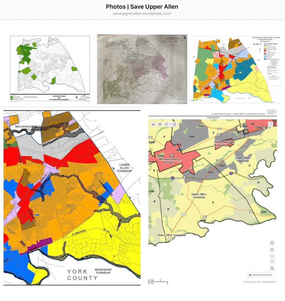
The future development potential for Upper Allen can be ascertained by studying the 5 maps above. Only 2 of these maps can be found on the Township website. The Township is 13.3 square miles or 8,512 acres. Here is a discussion of these maps:
.
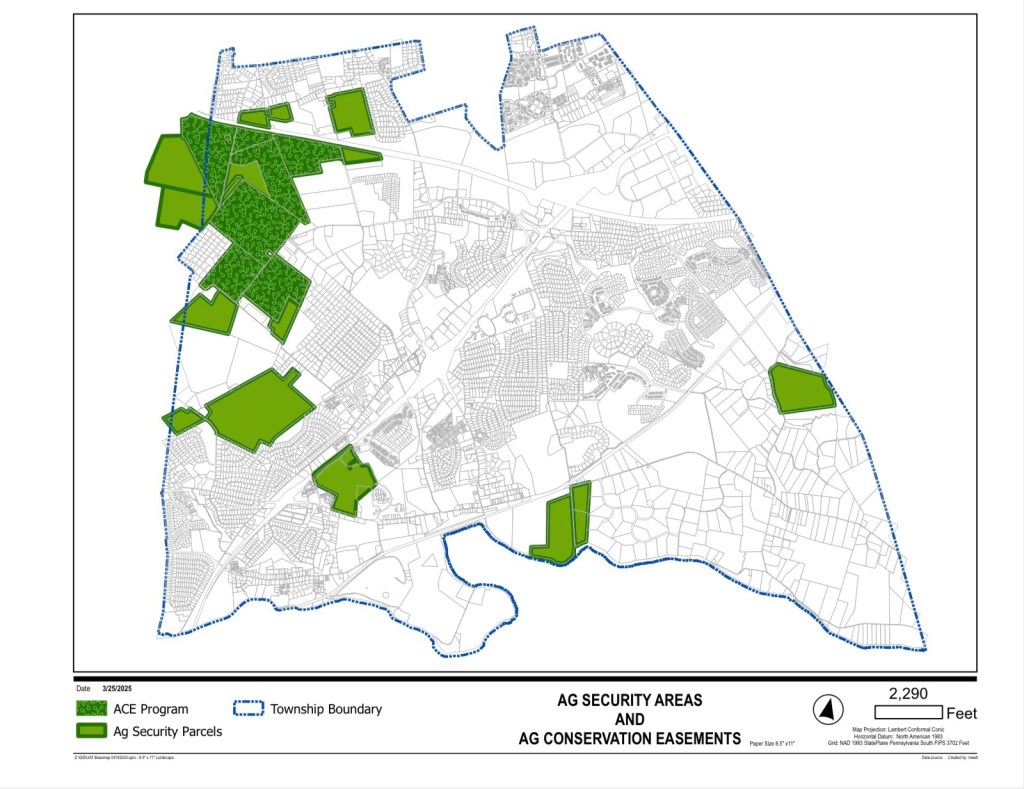
ASA/ACE Map:
.
We start with this map because it shows where development can not occur – on the 405 acres shown in Dark Green. These are the permanently preserved farms in the ACE program and they are concentrated in the North West portion of the township.
See our April 17, 2025 post on Land and Open Space preservation for more details. It is important to note the farms in ASA (medium Green) are not permanently preserved.
For example, the Lambert farm on McCormick Rd. was recently taken out of ASA to create Generations Park. It is also likely that Messiah University will soon want to develop its 48.65 acre tract on West Lisburn Rd. now in ASA.
Save Upper Allen advocates for a land preservation program similar to what Silver Spring offers. Land preservation programs are proven to pay for themselves and provide an effective/free market alternative to development.
Sewer Map:
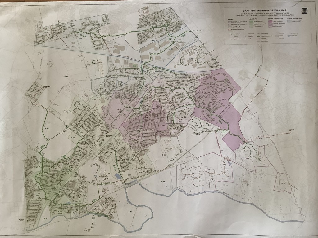
.
The map shows where Upper Allen presently has sewer facilities. In most cases, the closer land is to these facilities; the more easily and less expensively it can be developed.
Based on proximity to sewer; the larger UAT land tracts most at risk for future development are:
- Fisher and Stumpstown Rd. area. Several large tracts, mostly farmland not in ACE, totaling about 309 acres.
- East Lisburn Rd., Mt. Allen Dr., and (Western) McCormick Rd. Several large tracts, mostly farmland not in ACE, totaling about 376 acres.
- West Lisburn Rd., 48.65 acres farmland. Lisburn trunk line recently upgraded.
- Bishop Rd. Two tracts, one zoned institutional (Messiah), totaling 118 acres.
A quick back of the envelop calculation shows: at 4 units per acre, the 852 undeveloped acres noted above could generate 3,408 additional housing units.
Zoning Map:
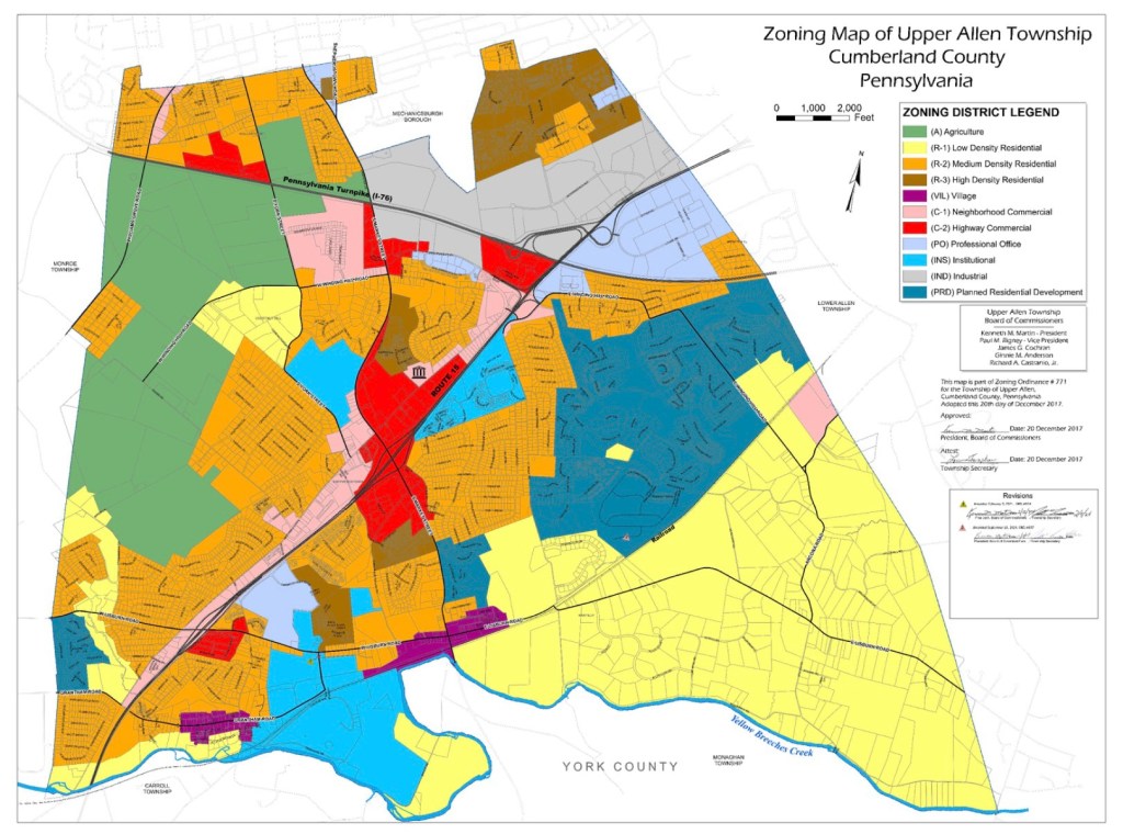
.
The Zoning Map shows the various zoning districts based on the December 20, 2017 rezoning of the entire Township plus some changes since. The Zoning Ordinance (Chapter 245 of Township Code) provides definitions for the various districts and what is allowable in each.
The major changes in 2017 were to expand commercial areas (C-1 and C-2) and to change the East Lisburn Rd. corridor from Agriculture/Rural Living to Low Density Residential (R-1). This is the large area now shown in Yellow. Minimum lot size was reduced from 5 acres to an option/formula based method that allows about 2 acres on average. Most residents were unaware of the 2017 changes.
Zoning changes since 2017 include the Tatterstall development and recent rezoning of the R-1 portion of Autumn Chase (14.8 acres) to R-2/PRD on September 18, 2024 by 3-2 vote. This allowed for the building on 22 homes vs. 8-10 under R-1.
The September, 2024 approval of the Autumn Chase re-zoning request demonstrates flaws in the zoning process; where, according to the current Solicitor, “impact on the school district could not be taken as a zoning matter”. The present UAT zoning ordinance clearly needs more “teeth”.
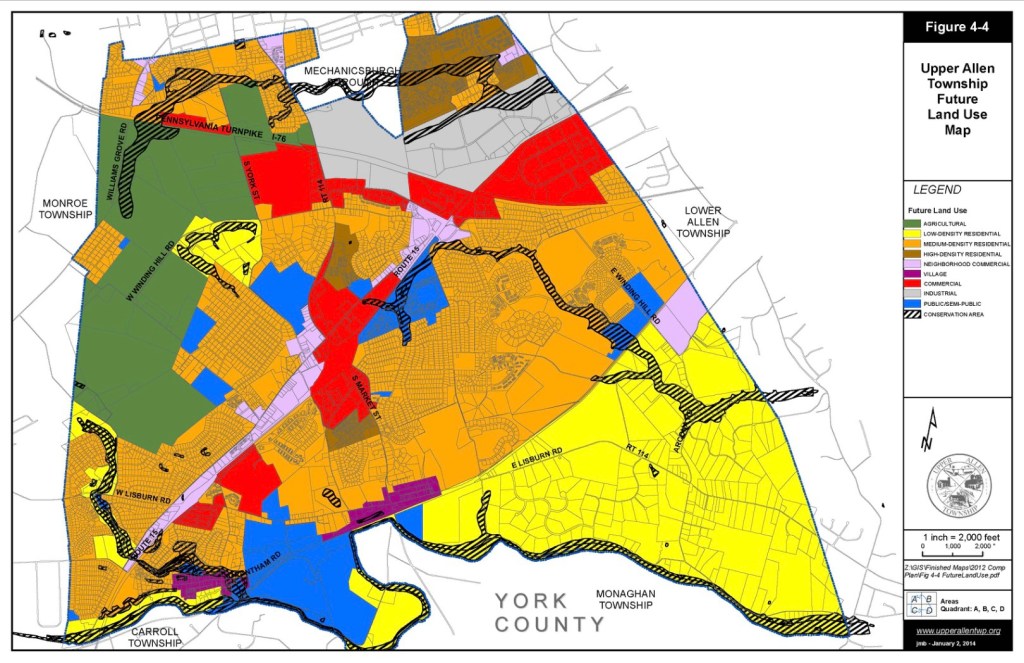
Future Land Use – UAT:
.
The future is yours to see – if you look carefully. This map was developed in 2013 as part of the Comprehensive Plan. Unbeknownst to most Upper Allen residents, it reveals where a small group of mostly pro-development individuals think we should build next.
Notable on this map is the continued shrinkage of Agriculture/farmland and increase of higher density residential and commercial development. One can see (in Red) what has become the Tatterstall development and the 48.65 acre tract along West Lisburn Rd. (now in ASA) which is shown as becoming Commercial.
The future land use map allows for developers to seek re-zoning so as to be “consistent” with this map. This is what the McNaughton Co. argued in its recent re-zoning request for 14.8 acres (near Pennington) to become R-2. (in Orange).
Of particular concern should be the 78 acre tract along East Lisburn and Mt. Allen Dr. (some call it the Simpson Farm) which is shown as becoming R-2. In addition to being a beautiful and historic property; it encompasses steep slopes and has a fair amount of tree cover backing up to Mt. Allen and Whitney Ridge developments.
Current R-2 zoning (see Orange on map) allows for 6 residential dwelling units per acre which are typically built as townhouses. If 50-60 acres of the above parcel were to be developed; it could easily mean 300 more housing units.
Future Land Use Map – County:
.
As part of its 2024 Comprehensive Plan; Cumberland County recently updated its Future Land Use map resulting in a significant portion of Upper Allen being changed from Rural/Agriculture (R) to Suburban (S). See homepage post from February 10, 2025.
Suburban is a broad land use category that includes (per the County’s definition) everything from single family housing, townhomes, apartments, commercial retail, office, and industrial uses with operations compatible with surrounding community.
The majority (pro-development) Commissioners are not concerned about the changes; whereas Commissioners Fairchild and Walsh are very concerned because it could lead to re-zoning requests.
There has been no formal review of this map by the Township; however, the County had offered to administratively amend its map to be reflective of Upper Allen’s wishes, so a meeting was arranged with Mr. Kirk Stoner of the County Planning Department to consider changes.
Commissioner Castranio was unable to attend; however Commissioner Fairchild met with Mr. Stoner on March 25, 2025. Here are the results of that meeting:
- East Lisburn Rd. and Western McCormick Rd. area to remain Rural
- Bishop Rd. (Eastern side) to remain Rural; Western side (was Institutional) to become Suburban
- West Lisburn Rd. (48.65 acre tract in ASA) to become Suburban
These changes should soon be reflected in the County’s map and we are grateful for the County’s consideration.
[Note, at a May 16, 2025 Administration meeting, we learned that there will Board discussion/action at an upcoming meeting to affirm these changes – or not.]
.
Bottom Line:
Upper Allen is at high risk for continued over development; especially if pro-development Commissioners remain in control. If you live near some of the un-preserved farms or larger land tracts, you should be concerned.
As noted elsewhere and in our February 12, 2025 homepage post; development doesn’t pay. It results in higher taxes because the township and school district end up funding much of the needed infrastructure and the cost to provide new services (more teachers, police, etc.) outpaces existing tax revenues.
Upper Allen tax millage has increased from .25 mills to 2.75 mills in 20 years and Mechanicsburg School District now has more bond debt ($150,145,000) than Cumberland Valley ($138,385,000).
Zoning can go only so far in addressing development.
The best and most effective way to limit future development is to have a land preservation program where large land owners are given an incentive to forgo developing their property.
Silver Spring started its own program in 2013 and is now on tract to preserve over 1,500 acres vs. Upper Allen which has 405 acres preserved. Silver Spring’s property tax is at 1.30 mills and its EIT rate is 1.70%
Upper Allen Township can and should have its own preservation program. Our April 17, 2025 post explains how a program can be started using existing funding without raising taxes.
[This post was cross posted on Upper Allen Community Facebook page on May 2, 2025 – and subsequently removed by its administrator]
.
Current Development
October 16, 2023

Hundreds more housing units have already been approved and commercial development is being egged on by taxpayer subsidies for the Veolia water tower, etc. There is also a nearly $3 million sewage plant upgrade in process. More fast food and a car wash are on the way. A new sign ordinance is in the works that could result in billboards every 500 ft. along highways.
A summary of current Upper Allen development plans can be found here
https://uatwp.org/community/development-projects/
Unrestrained development degrades our quality of life and impacts local government finances. It clogs our roads and stresses our school system. Instead of amending Zoning to better control development, the incumbents continue to say “our hands are tied”. This is both incorrect and foolish. We can indeed control the type of community we want to live in.
Eric and Phill will advocate for “smart growth” Here is the “basic concept” per Wikipedia:
“Smart growth is a theory of land development that accepts that growth and development will continue to occur, and so seeks to direct that growth in an intentional, comprehensive way. Its proponents include urban planners, architects, developers, community activists, and historic preservationists. The term “smart growth” is an attempt to reframe the conversation from “growth” versus “no growth” (or NIMBY) to good/smart growth versus bad/dumb growth. Proponents seek to distinguish smart growth from urban sprawl, they claim causes most of the problems that fuel opposition to urban growth, such as traffic congestion and environmental degradation. Smart growth principles are directed at developing sustainable communities that provide a greater range of transportation and housing choices and prioritize infill and redevelopment in existing communities rather than development of “greenfield” farmland or natural lands. Some of the fundamental aims for the benefits of residents and the communities are increasing family income and wealth, providing safe walking routes to schools, fostering livable, safe and healthy places, stimulating economic activity (both locally and regionally), and developing, preserving and investing in built and natural resources.” For further info, see:
https://en.wikipedia.org/wiki/Smart_growth
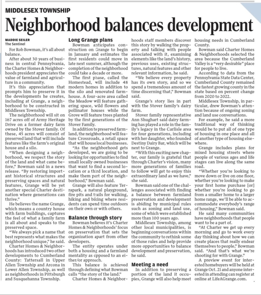
Local examples of smart growth might include the original Mills at Shepherdstown (before Chick-Fil-A), Lower Allen’s redevelopment of the former Bon-Ton site (including Chick-Fil-A), and “Grange”, a new mixed use neighborhood in Middlesex Township that will sit on a former 167 acre dairy farm , with 45 acres of preserved land including meadows, trails, woods and the farm’s original house and silo.
Here are further details on “Grange” per an August 15, 2023 article in the Carlisle Sentinel.